


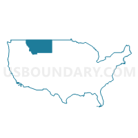
East Montana (Outside Billings City) PUMA, Montana
About
Outline
+PUMA%2c+Montana_A280.png)
Summary
| Unique Area Identifier | 193321 |
| Name | East Montana (Outside Billings City) PUMA |
| State | Montana |
| Area (square miles) | 59,160.15 |
| Land Area (square miles) | 58,578.28 |
| Water Area (square miles) | 581.87 |
| % of Land Area | 99.02 |
| % of Water Area | 0.98 |
| Latitude of the Internal Point | 46.93456970 |
| Longtitude of the Internal Point | -106.36402380 |
Maps
+PUMA in Montana.png)
Graphs
Select a template below for downloading or customizing gragh for East Montana (Outside Billings City) PUMA, Montana
+PUMA%2c+Montana_T0.png)
+PUMA%2c+Montana_T1.png)
+PUMA%2c+Montana_T2.png)
+PUMA%2c+Montana_T3.png)
+PUMA%2c+Montana_T4.png)
+PUMA%2c+Montana_T5.png)
+PUMA%2c+Montana_T6.png)
+PUMA%2c+Montana_T7.png)
+PUMA%2c+Montana.png)
Neighbors
Neighoring Public Use Microdata Area (by Name) Neighboring Public Use Microdata Area on the Map
- Billings City PUMA, MT
- Campbell, Goshen, Platte, Johnson, Washakie, Weston, Crook & Niobrara Counties PUMA, WY
- North Central Montana--Great Falls City PUMA, MT
- Sheridan, Park, Teton, Lincoln & Big Horn Counties PUMA, WY
- South Central Montana--Bozeman City PUMA, MT
- West North Dakota--Minot City PUMA, ND
- West South Dakota--Rapid City PUMA, SD
Top 10 Neighboring County (by Population) Neighboring County on the Map
- Yellowstone County, MT (147,972)
- Campbell County, WY (46,133)
- Sheridan County, WY (29,116)
- Williams County, ND (22,398)
- Big Horn County, MT (12,865)
- Custer County, MT (11,699)
- Big Horn County, WY (11,668)
- Fergus County, MT (11,586)
- Roosevelt County, MT (10,425)
- Butte County, SD (10,110)
Top 10 Neighboring County Subdivision (by Population) Neighboring County Subdivision on the Map
- Billings CCD, Yellowstone County, MT (107,934)
- Gillette North CCD, Campbell County, WY (30,768)
- Sheridan CCD, Sheridan County, WY (21,451)
- Laurel CCD, Yellowstone County, MT (15,847)
- Miles City CCD, Custer County, MT (10,544)
- Lewistown CCD, Fergus County, MT (9,097)
- Fort Peck Reservation CCD, Roosevelt County, MT (8,847)
- Glendive CCD, Dawson County, MT (8,016)
- South Yellowstone CCD, Yellowstone County, MT (7,653)
- Northwest Yellowstone CCD, Yellowstone County, MT (7,558)
Top 10 Neighboring Place (by Population) Neighboring Place on the Map
- Billings city, MT (104,170)
- Miles City city, MT (8,410)
- Lockwood CDP, MT (6,797)
- Laurel city, MT (6,718)
- Sidney city, MT (5,191)
- Glendive city, MT (4,935)
- Hardin city, MT (3,505)
- Glasgow city, MT (3,250)
- Wolf Point city, MT (2,621)
- Colstrip city, MT (2,214)
Top 10 Neighboring Elementary School District (by Population) Neighboring Elementary School District on the Map
- Billings Elementary School District, MT (107,977)
- Laurel Elementary School District, MT (11,043)
- Miles City Elementary School District, MT (9,934)
- Hardin Elementary School District, MT (9,478)
- Lewistown Elementary School District, MT (8,626)
- Lockwood Elementary School District, MT (7,865)
- Sidney Elementary School District, MT (6,817)
- Glendive Elementary School District, MT (6,441)
- Wolf Point Elementary School District, MT (4,205)
- Roundup Elementary School District, MT (4,109)
Top 10 Neighboring Secondary School District (by Population) Neighboring Secondary School District on the Map
- Billings High School District, MT (127,987)
- Custer County High School District, MT (11,699)
- Laurel High School District, MT (10,696)
- Fergus High School District, MT (9,002)
- Dawson High School District, MT (8,479)
- Hardin High School District, MT (8,178)
- Sidney High School District, MT (7,392)
- Lame Deer High School District, MT (5,376)
- Wolf Point High School District, MT (4,635)
- Roundup High School District, MT (4,246)
Top 10 Neighboring Unified School District (by Population) Neighboring Unified School District on the Map
- Campbell County School District 1, WY (46,133)
- Sheridan County School District 2, WY (24,064)
- Belle Fourche School District 09-1, SD (7,962)
- Crook County School District 1, WY (7,083)
- Glasgow K-12 Schools, MT (4,951)
- Sheridan County School District 1, WY (4,623)
- Huntley Project K-12 Schools, MT (4,244)
- Malta K-12 Schools, MT (3,211)
- Bowman County Public School District 1, ND (2,714)
- Baker K-12 Schools, MT (2,470)
Top 10 Neighboring State Legislative District Lower Chamber (by Population) Neighboring State Legislative District Lower Chamber on the Map
- State House District 46, MT (13,942)
- State House District 2, ND (13,822)
- State House District 39, ND (13,645)
- State House District 52, WY (12,056)
- State House District 57, MT (11,941)
- State House District 47, MT (10,977)
- State House District 48, MT (10,702)
- State House District 55, MT (10,488)
- State House District 58, MT (10,094)
- State House District 56, MT (10,028)
Top 10 Neighboring State Legislative District Upper Chamber (by Population) Neighboring State Legislative District Upper Chamber on the Map
- State Senate District 23, WY (26,474)
- State Senate District 23, MT (23,380)
- State Senate District 29, MT (22,035)
- State Senate District 24, MT (21,679)
- State Senate District 28, MT (20,516)
- State Senate District 42, MT (20,506)
- State Senate District 28, SD (19,903)
- State Senate District 22, WY (19,515)
- State Senate District 22, MT (19,347)
- State Senate District 30, MT (19,092)
Top 10 Neighboring 111th Congressional District (by Population) Neighboring 111th Congressional District on the Map
- Congressional District (at Large), MT (989,415)
- Congressional District (at Large), SD (814,180)
- Congressional District (at Large), ND (672,591)
- Congressional District (at Large), WY (563,626)
Top 10 Neighboring Census Tract (by Population) Neighboring Census Tract on the Map
- Census Tract 14.01, Yellowstone County, MT (9,227)
- Census Tract 7, Campbell County, WY (8,828)
- Census Tract 9400, Yellowstone County, MT (7,653)
- Census Tract 7.02, Yellowstone County, MT (7,400)
- Census Tract 5, Sheridan County, WY (6,541)
- Census Tract 13, Yellowstone County, MT (6,124)
- Census Tract 18.02, Yellowstone County, MT (5,952)
- Census Tract 14.02, Yellowstone County, MT (5,634)
- Census Tract 9628, Big Horn County, WY (5,571)
- Census Tract 18.01, Yellowstone County, MT (5,321)
Top 10 Neighboring 5-Digit ZIP Code Tabulation Area (by Population) Neighboring 5-Digit ZIP Code Tabulation Area on the Map
- 59102, MT (46,564)
- 59101, MT (39,562)
- 59105, MT (29,624)
- 82801, WY (24,558)
- 58801, ND (18,371)
- 59106, MT (12,375)
- 59301, MT (11,404)
- 59044, MT (10,971)
- 59457, MT (9,105)
- 59330, MT (8,307)